
Day 9 - Oct 10th , 2015
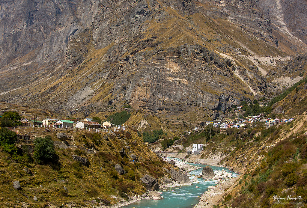
Joshimath (earlier known as Jyotirmath ) is one of the four ‘maths’ discovered by Adi Guru Shri Sankaracharya in the 8th century AD. The place is highly revered by Hindus and is an important pilgrimage centre in the country. Many devotees and travelers can be seen in the area during the summer season. There are many temples and other religious sites that are located in the town as well.
Joshimath at an altitude of 2100 mts, is a town with religious importance in Uttarakhand. It is also the junction point for people visiting Auli, one of the best skiing spots in India. It is also the main base point for Badrinath.
Char Dham Yatra and Joshimath
Many pilgrims take night halt at Joshimath, during their char dham yatra. The road distance from Rishikesh to Joshimath is 251 km via Rudraprayag, KaranPrayag, Srinagar and Chamoli.
During winter season, the ‘Utsav Murti’ (idol used for public functions and to move around the temple) of Lord Badrinath is worshipped in Narasimha Temple at Joshimath.
Gate System in Joshimath
Departure from Joshimath to Badrinath is controlled by what is known as the ‘gate’ system. There are two stretches on this road that are so narrow that two-way heavy traffic is impossible. Queued up vehicles from both Joshimath and Badrinath are released at fixed intervals and timings at a nearby place.
There are certain timings for Gate release. Once released from Joshimath or Badrinath the traffic then stops again at Pandukeshwar (the approximate mid-point), which allows a short two-way. These vehicles cross each other here, and thereafter it is again one-way traffic.
Badrinath
We started from Joshimath by 5AM, after a small Chai break, and hoped to see the sunrise enroute. Most of the people in the car dozed off , while myself and Sandeep were talking about the road consitions.
Slowly, the light began to increase (Tamasoma Jyotirgamaya ...), and we could see the surroundings clearly. The only sounds that were heard was that of the gushing waters of the Alakananda river, the engine of our vehicle and the snore of the sleeping souls :)
The road to Badrinath is truly adventurous , as one can expect the unexpected. Landslides are very common and the roads are completely broken. The path is very narrow, and vehicles coming from both the sides, crossing each other dangerously.
One side of the road is Alakananda valley, and the other side is the mighty mountain. The never ending turns on the road, rocks and boulders spread over the route, makes this a bumpy-jumpy ride. But, all the pain vanishes once the holiest of the town "Sri Badrinath" is arrived.


Road that leads to Badrinath
 Alakananda valley - Photographed from Mobile phone


Badrinath is a holy town in the Chamoli district of the state of Uttarakhand, India. It is the most visited of the four sites in India's Char Dham pilgrimage, and gets its name from the temple of Badrinath.

Badrinath has an average elevation of 3,100 metres (10,170 feet). It is in the Garhwal Himalayas, on the banks of the Alaknanda River. The town lies between the Nar and Narayana mountain ranges 9 km east of Nilkantha peak (6,596m).


Golden Hues


Mountains and Alaknanda river


Nilkanth peak


Play of Lights and Shades


Nilkanth peak and Badrinath town

The Satopanth Glacier lies on the northwest side of Nilkanth, The Panpatia Glacier lies to the southwest. Further away, to the west of the peak, lies the well-known Gangotri Glacier and its associated peaks. Across the Alaknanda valley lie the Kamet and Nanda Devi groups.


Alaknanda river

Badrinath temple


Alaknanda river and Badrinath town

Taptakund
The Tapt Kund, a group of hot sulphur springs just below the temple, are considered to be medicinal. Many pilgrims consider it as a requirement to bathe in the springs before visiting the temple. The springs are hot throughout the year.

Entrance of Badrinath temple

At the gate, directly opposite to the main Idol of the Lord himself, is seated the idol of Bird Garuda, the vehicle of Lord Badrinarayan, sitting in prayer with his hands folded. The walls and pillars of the mantapa are covered with carvings.

Nilkanth peak and Badrinath temple

The Garbha Griha portion has its canopy covered with a sheet of gold, and houses Lord Badari Narayan, Kuber (God of wealth), Narad rishi, Udhava, Nar & Narayan. The complex has 15 idols especially attractive is the one-metre high image of lord Badrinath, finely sculpted in black stone.According to legend Shankara discovered a black stone image of Lord Badrinarayan made of Saligram stone in the Alaknanda River. He originally enshrined it in a cave near the Tapt Kund hot springs. In the sixteenth century, the King of Garhwal moved the murti to the present temple. It represents Lord Vishnu seated in a meditative pose called padmasan.

The main entrance gate of Badrinath temple is colourful & imposing popularly known as Singhdwar. The temple is approximately 50 feet tall with a small cupola on top, covered with a gold gilt roof.

Darshan Mantap: Lord Badari Narayan is armed with Conch and Chakra in two arms in a lifted posture and two arms rested in Yogic Pose. Badarinarayan is seen under the Badari tree, flanked by Kuber and Garuda, Narad, Narayan and Nar. As you look, standing to the right side of Badrinarayana is Uddhava. To the far right side are Nara and Narayana. Narada Muni is kneeling in front on the right side and is difficult to see. On the left side are Kubera-the god of wealth, and a silver Ganesh. Garuda is kneeling in front, to the left of Badrinarayana.

Temple windows
Sabha Mandap: It is a place in the Temple complex where devotees and pilgrims assemble.
Badrinath temple is open only during April/May - Oct end (Diwali time). The temple committee decides the opening and closing dates of the temple.
Mana
We then proceeded towards Mana, which is very close to Badrinath. Mana is officially the "Last Indian Village" near China border, in this region .
We reached Mana by 11.30AM, but we could not visit any other place nearby as time was short, and we had to go back to Chopta.
We reached Mana by 11.30AM, but we could not visit any other place nearby as time was short, and we had to go back to Chopta.
We just wanted to step in the "Last Indian Village" :)
Mana is a village in the district of Chamoli in the Indian state of Uttarakhand, located at an altitude of 3,200 meters. Mana is the last village before the Mana Pass and is 24 kilometres from the border of India and Tibet/China. The village is at a distance of about 3 km from the Hindu Pilgrimage Badrinath and the two places are culturally connected with each other.
Mana is a small village stuck in time – one has to park their vehicles at the village border itself, and walk around on foot, thus giving you a chance for a refreshing walk in the midst of the heavenly Himalayan surroundings


Alaknanda at Mana

Portrait of a local woman

Board says it all ...
There are many sight seeing places around Mana, like the Vasudhara Falls , Satopanth Glacier , Vyas gufa , Saraswathi kund , Bhim Phul , Brahma Kapal etc
All these places are worth visiting, but proper planning is required.
We departed from Mana around 12.15 PM, and proceeded towards Chopta.
Enroute Chopta, we met a forest official at Gopeshwar (Satish uncle's friend)
and had a good "Chai pe charcha" with him.
Enroute Chopta, we met a forest official at Gopeshwar (Satish uncle's friend)
and had a good "Chai pe charcha" with him.
Getting There ...
By Air: The nearest airport from Badrinath is the Jolly Grant Airport near Dehradun, about 320 km from Badrinath. Next best is the Indira Gandhi airport at Delhi, 535kms from Badrinath.
By Helicopter: The distance by a helicopter journey is hardly 100 km. There are many providers of helicopter service from Dehradun to Badrinath.
By Train: The nearest railway stations to Badrinath are at Rishikesh (300 kms), Haridwar (324 kms) and Kotadwar (327 kms). Rishikesh is not connected by fast trains and Kotadwar has very less number of trains.
By Bus: Badrinath is easily accessible by road. It is located at a distance of 535 Km from Delhi , 300 Km from Rishikesh. There are regular buses operating to Badrinath from Delhi, Haridwar and Rishikesh.
By Helicopter: The distance by a helicopter journey is hardly 100 km. There are many providers of helicopter service from Dehradun to Badrinath.
By Train: The nearest railway stations to Badrinath are at Rishikesh (300 kms), Haridwar (324 kms) and Kotadwar (327 kms). Rishikesh is not connected by fast trains and Kotadwar has very less number of trains.
Thus, Haridwar serves as the best railway station if you are visiting Badrinath by train. Haridwar is connected by many trains from all parts of India.
By Bus: Badrinath is easily accessible by road. It is located at a distance of 535 Km from Delhi , 300 Km from Rishikesh. There are regular buses operating to Badrinath from Delhi, Haridwar and Rishikesh.
Regular buses operate from Rishikesh bus station to Badrinath and start very early before dawn. The road is narrow after Joshimath and travel is not permitted on the road after sunset. Therefore if one misses the bus for Badrinath at Rishikesh bus station, one has to go only up to Rudraprayag, Chamoli or Joshimath and spend the night there to take the early morning bus for Badrinath.
Well connected to Haridwar , Rishikesh, Dehradun , Dev Prayag, Rudra Prayag, Kotdwar, Joshi Math and other hill stations of Garhwal and Kumaon region.
Our route ...
Joshimath - Vishnu Prayag - Govind ghat - Pandukeshwar - Hanuman Chatti - Badrinath - Mana (48 kms from Joshimath to Mana)
Mana - Badrinath - Joshimath - Pipalkoti - Chamoli - Gopeshwar - Chopta (approx 190 kms)
Mana - Badrinath - Joshimath - Pipalkoti - Chamoli - Gopeshwar - Chopta (approx 190 kms)


Great photographs. I really would like you to visit my travel and photo blog www.everythingcandid.com
ReplyDeleteI am sure you would love it. I a totally in love with your bog and would keep exploring it.
Thanks a lot Himanshu !!
DeleteWill surely go through your blog as well.
HATS OFF !! My friend for such beautiful blog and illustrations, classic images, it is surely can take place in "Travelers Guide" you have given us all insight into travelling these places, blessed you are and your family, I would like to mention instead of calling it a team it should be "Family' only and what a family of same tastes and vigour.
ReplyDeleteThe image of Amika & Satish jogging seems to like a dancing steps....one two cha cha...you and me cha cha...hehehe :)
The sun kissed mountains, snowscapes, mountain scapes are just awesome. Yes images of rare birds [not seen in this region], and particularly the Himalayan Griffon is exemplary .
Also your star trails, milky way shots are too good, you are mastering them I feel.
Do you keep penning / making notes as you travel or come back and rewind your memory? whatever you have one good talent....
Keep blogging and keep on your Sojourn....going
Cheers,
Chandru
Thank you very much Chandru uncle.
DeleteI generally don't pen down anything, just remember and recollect them while writing the blog.