
The second monsoon trek in this year, was a venture to the floral wonderland called Kurinjikallu. (My first monsoon trek of the season was to : Tadiyandamol )
Some people call it as Kurinjikallu and some call it as Kurinjal.
Mr.Vishwanath of Summiters had organized a trek to this beautiful hidden peak of the western ghats. Once the trek was planned, few friends and I decided to join.
We boarded the tempo traveler on July 24th (Friday night) and after picking up fellow trekkers , we departed from Bangalore by 11.30 PM. Before we could even realize, the pre-trek session had started. The small intro session grew to a long discussion about our previous treks, recollecting the golden memories of the past.
The group woke up to the cool breeze and mist at Kottigehara, which is a small sleepy hamlet in the Western ghats. This place is the gateway to Kudremukh and Hornad (a shrine of Goddess Annapoorneshwari).
The strain due to less sleep vanished after having a cup of filter coffee at Kottigehara.
Once the bookings and permit transactions were done at Kudremukh forest office, we headed towards 'Bhagwathi Nature Camp'.
Couple of Grey Hornbills welcomed us at Kudremukh :)

We had a quick breakfast , packed our bags and started to conquer Kurinjikallu.
For some, the trek experience was a debut. Hence, we briefed them about the trek, and the things that were to be expected.
Bhagawathi Nature Camp is one of the most scenic nature camps situated in Karnataka. It is situated in the Kudremukh Wildlife sanctuary and is surrounded by thick rainforests.

For some, the trek experience was a debut. Hence, we briefed them about the trek, and the things that were to be expected.
About Bhagavathi Nature Camp
Bhagawathi Nature Camp is one of the most scenic nature camps situated in Karnataka. It is situated in the Kudremukh Wildlife sanctuary and is surrounded by thick rainforests.

The nature camp is the starting point for many treks and provides great opportunities for birding and herping. Macro photographers find this place a true hotspot.

The beauty of this camp is , all the cottages are given a name of an animal/bird. This induces some knowledge among the children as it increases their inquisitiveness.

The beauty of this camp is , all the cottages are given a name of an animal/bird. This induces some knowledge among the children as it increases their inquisitiveness.

Other peaks that are near Bhagawathi camp are :
Kudremukh peak - 17km
Gangadikal peak - 4 km
Sitabhumi peak - 15 km
Valikunja - 14 km
Narsimha parvatha - 19 km

(Image courtesy : Bhargav AK)
Trek to Kurinjal
Before the trek started, the rain gods welcomed us. All the jackets and raincoats came up eventually. Due to this, the visibility was low for quite sometime, and then the mist began to clear.

The trail looked very attractive, but many were unaware of the small vampires(Leeches).


The path leads to a small bridge, which is probably built across the river Bhadra. A little later, we crossed this bridge amidst rain and mist. The view from this bridge was amazing as we could see, Green.. Green.. and only Green.


Once the bridge was crossed, everybody started to check for Leeches. Leech bite was a first experience for few people and they began to act crazily :)

The trail that connects Sholas and Grasslands

Monsoon treks has its own limitations. The rain makes the trail slippery and the number of Leeches increase. The mist too plays its role in the visibility factor.

Apart from that, monsoon transforms the whole western ghats to a wonderland.
Each tree has its own story in the ghats. From the ground, the canopy is hardly visible and the roots of each tree is very significant and extremely unique.
Few fallen trees decreased the speed of our trek, thus by giving time for leeches to attack us.

The leech density was very high and it was a real challenge to remove them. Even though we had salt and other anti-leech items, we could not stop for a long time. Hence the trekking speed increased.

The rains started again and we were all completely drenched. Western ghat rains are always special, as it has a lot of energy and density. The trail was completely water clogged and all the puddles were filled. Eventually, a small stream originated on our path.

(Image courtesy : Venkatesh Penjuri)
After a long walk in the sholas, we were finally out in the open. The mist made us to wait for some time, to witness the grand beauty. I was mesmerized to see the whole Kudremukh range from this point.


After crossing the rocky path, the inclination increased. A tower and an abandoned house was faintly visible from this point. The mist had engulfed by then.
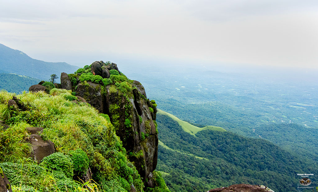
A few steps further, we encountered a small patch of shola. After crossing this, the first glimpse of Kurinjal / Kurinjikallu peak was visible.

The big rock at the backdrop is Kurinjal. The sight of the peak was a big energizer to all of us, and this made our strain disappear.

Still a long way to go

(From L to R : Ambika , Satish , Teju , Umesh)

( Team picture
From L to R : Vishwa , Madhusudhan , Umesh , Bhargav , Prasanna(guide) , Ambika , Karthik , Satish , Abhishek , Vinayak , Sandeep , Teju , Venkatesh)
I am behind the camera as usual :)
After a brief Photography and Leech removal session, we proceeded towards the summit.

The trail that proceeds towards the abandoned house is quite challenging as the path is covered with thorny plants, pits and rocks .

The house was constructed at a great height in midst of thick forest. We really wondered about the history of its construction.

The final stretch was quite difficult. We had to climb rocks that were very slippery, and steep. Thanks to rain for making our journey quite challenging.

Peak is near !

Summiters at the summit
Valley seen from the peak


Lakya dam as seen from the peak
 Panorama
(Image courtesy : Venkatesh Penjuri)

(Image courtesy : Venkatesh Penjuri)


Descent was much easier. The gradient was the vast meadows of green carpet. All small puddles were filled due to heavy rainfall.

Eating while Posing
We had our lunch at the abandoned house after climbing down from the peak. The lunch consisted of Chapathi and Tomato gojju, which was incredibly delicious.

Enjoying the view with colors

A vibrant grasshopper

Rains had stopped and the route was clear. But the leechy path was slippery and slushy. The Leech menace increased during the descent.


Back to track
Everyone was busy in removing Leeches, while I was clicking photographs knowing that I have donated the maximum blood.
From the main road, we had to trek almost 1.5 kms to the Nature camp and upon arrival, we wondered where all the leech had bitten us, making everybody busy in finding it out :)
The funny part was, Leeches had encroached our imaginations, making us think even a small stick to look like a leech.

My leg after the blood donation camp :)
Many did a generous contribution of blood, but myself and Abhishek were the highest contributors and felt proud about that :)
The evening snack of Onion Pakoda was then followed by a sumptuous dinner.
Later, each one of us hit the bed for a well deserved sleep.
Although the season of Kurinji flowers was over, we still enjoyed the beautiful panoramic views of the Kudremukh range.
Information for trekkers
Total trek distance : 15 kms (ascent and descent)
Best time : Sep to Feb , mid May to mid June (If you do not wish to trek in rains). July-Aug is a good time for monsoon lovers
Distance from Bangalore : Approx 350 kms
Nearest town : Kudremukh
Nearest campsite : Bhagawathi Nature camp
Camping : Not allowed
Permission : Forest department permission is necessary
Trek level : Easy to Moderate
What to expect : Good views of Kudremukh range , Kurinji flowers (seasonal)
You can book here for your next trek : Kurinjal trek through Summiters
You can book here for your next trek : Kurinjal trek through Summiters
Why is it called Kurinjikallu/Kurinjal?
Kurinji(Strobilanthes kunthiana) is the famous flower that makes the Neelgiri hills blue. Kurinji is a bright blue bell-shaped flower found on the hill slopes of the Western Ghats at an altiltude between 6000 to 7000 feet. The unique feature of this flower is that it blooms once in 12 years, and transforms the whole mountain slopes to a wonderful blue carpet.
This valley is home to one of the most endemic flower of the western ghats. Hence the name, Kurinjikallu Betta.

(Kurinji flower : Image Courtesy - Vishwanath)
Don't litter the place.
Take nothing but photographs, Leave nothing but footprints


Nice post arjun!
ReplyDeleteThank you :)
DeleteDedication, persistence, aiming for the best, challenging are some of the characters, you posses and hence all these are possible. The photographic aspect is one part, which is amazing, also, is the difficulty in trekking in spite of the vampire Leeches, are most appreciable. The quality of images and notes are improving terrifically blog by blog. superb as usual.
ReplyDeleteThanks a lot for the kind words and appreciation chikappa :)
DeleteUseful info and nice photos! Good job, Arjun :)
ReplyDeleteThanks a lot Sudhir :)
DeleteThanks a lot Bhargav :)
ReplyDeletewonderful Arjun :)
ReplyDeleteThanks Santosh :)
DeleteWonderful write up and fantastic photos
ReplyDeleteWonderful !
ReplyDeleteI have seen the place ith great joy!
Only no leech bites.
Regards
Sivakumar
Thanks a lot sir :)
DeleteHey like all your blogs, this one too tell us the story clear and loud, with illustrating images and notes, no doubt you are good blogger when it comes to trekking. I enjoyed the journey and pictures, wish I could see little more of macro work, nevertheless the landscapes, tree scapes are good. Keep it up...
ReplyDeleteThanks a lot Chandru uncle :)
DeleteI will try to post more macro in further blogs.
Amazing clicks...and picturesque place....
ReplyDeletewould be grateful if more info is given!
amazing place. great post dear
ReplyDelete