
Part 1 - Kurinjal trek (click here to read the Kurinjal experience)
It had rained the whole night, and the next morning was very calm and serene. The already green Nature camp at Kudremukh had turned to be more vibrant. We spent some time at the small stream that flows near the camp.


There are around 13 trekking trails in Kudremukh, and Gangamoola is an interesting one.

Trekkers have to get permission from the Forest Department for taking up trekking trips here.

The trails will take you through the jungle, crossing streams and rivers and coming across beautiful waterfalls, cave temples, ruins and a wide variety of bird and animal life and lush greenery.
The origin of trekking begins from a dark cave underneath huge rocks. Water trickles at several places in between rocks inside the cave and it is advisable to carry a torch, even during the day.

Far away from the busy life of the city and its pollution filled environment, this gorgeous waterfall is a fine example of natural exquisiteness existing in the rainforests of Karnataka.
After crossing these small waterfalls, exploring caves and climbing rocks, the group was split. One part of the group went in a different direction and the second part in another direction.

Bhargav, CG , Venky , Umesh , Satish , Ambika , Madhu and Myself were lost. This lost trail was mesmerizing as I had never trekked in such a terrain before. The rains made the soil slippery, and many tree branches were breaking.

We had to climb down along an undefined path. We made our own path and started to move on by holding tree roots , walking on rocks , sliding on mud and crossing fallen trees etc. It as a fully adventurous trek which will be etched on our minds forever.
Amidst all this, the thorns and leeches were constantly troubling us :)

We finally joined the other members of our team after a hard communication.
For nature lovers, the waterfall offers not only a mesmerizing visual but also a serene atmosphere to absorb the beauty.


Day 2 :
It had rained the whole night, and the next morning was very calm and serene. The already green Nature camp at Kudremukh had turned to be more vibrant. We spent some time at the small stream that flows near the camp.

Game of splashes

Milky flow
After an amazing trek to Kurinjal the previous day, we were supposed to trek the Gangadikal peak this morning (July 26th , Sunday). But due to some permission issues , we were denied entry to Gangadikal but got permission to trek Gangamoola instead.
We started from Bhagavathi Camp after having a tasty breakfast. On the way to Gangamoola, we visited Kadamby falls.
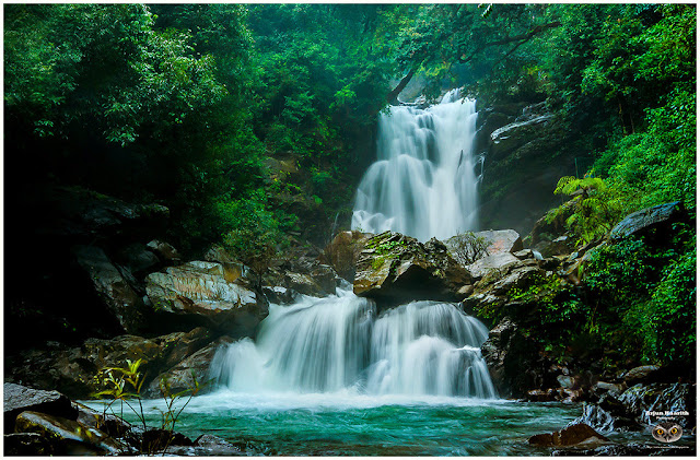
Kadambi Falls :
Kadambi Waterfalls is one of the spectacular natural attractions of Karnataka. The falls is located inside the Kudremukh National Park in the Chikmagalur district of Karnataka.

The Kadambi Waterfalls are a major draw for tourists who want to experience the beauty of nature in the lush green Western Ghats and especially in the Kudremukh range. It lies close to the main road between Sringeri & Kudremukh. As it is very close to the main road, it can be seen from a bridge situated nearby.

The Kadambi Waterfalls is a stunning sight to behold. In the abounding greenery of the place, the majestic waterfall stands out as a stream of sparkling whiteness rushing down the rocks.

During the monsoon season the waterfall comes alive with full force. At such times the beauty of the waterfall is enhanced by many degrees. It is an amazing sight to watch the water making its own way through the rocks at any time of the year, but watching it during monsoons is a different experience altogether.
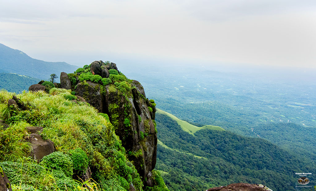
Gangamoola
Trekking in Gangamoola can be a pleasant experience, as you walk through dense jungles, cross rivers , streams and cascading waterfalls.
Ganga Moola can be reached by trekking for about 2 Kms from the main road between Sringeri & Kudremukh.

It is a hill in the Western Ghats, and is part of the Gangamoola-Aroli-Gangrikal hill range. Rising 1,458 meters above sea level, this region receives a lot of rainfall and so is covered with dense rainforests. It is located in the Chikmagalur district, Samse Taluq, Karnataka. Gangamoola has been designated a World heritage Site by UNESCO. This hill range is the source of three rivers – Tunga, Bhadra and Netravathi. It is also part of the Kudremukh bio-diversity cluster.

Gangamoola is also known as Varaha Parvata. Inside the dense jungle of this region, there is a temple dedicated to Goddess Bhagavathy and a 1.8 meter tall image of Varaha inside a cave. This cave becomes inaccessible during the monsoon season.

Gangamoola, which is within the bounds of the Kudremukh National Park, is rich in wildlife. This is also a bird lover’s paradise; as many species of birds have been identified here.

There are around 13 trekking trails in Kudremukh, and Gangamoola is an interesting one.

Trekkers have to get permission from the Forest Department for taking up trekking trips here.

The trails will take you through the jungle, crossing streams and rivers and coming across beautiful waterfalls, cave temples, ruins and a wide variety of bird and animal life and lush greenery.
The origin of trekking begins from a dark cave underneath huge rocks. Water trickles at several places in between rocks inside the cave and it is advisable to carry a torch, even during the day.

Far away from the busy life of the city and its pollution filled environment, this gorgeous waterfall is a fine example of natural exquisiteness existing in the rainforests of Karnataka.
After crossing these small waterfalls, exploring caves and climbing rocks, the group was split. One part of the group went in a different direction and the second part in another direction.

(Image courtesy : Venkatesh)

We had to climb down along an undefined path. We made our own path and started to move on by holding tree roots , walking on rocks , sliding on mud and crossing fallen trees etc. It as a fully adventurous trek which will be etched on our minds forever.
Amidst all this, the thorns and leeches were constantly troubling us :)

We finally joined the other members of our team after a hard communication.
For nature lovers, the waterfall offers not only a mesmerizing visual but also a serene atmosphere to absorb the beauty.

It is a splendid destination that rejuvenates the soul and relaxes the mind.
1) River Tunga flows towards north passing the towns of Sringeri, Thirthahalli and Shimoga. After flowing for 147 kms, it joins the River Bhadra at Koodli near Shimoga to form Tungabhadra River.
2) River Bhadra flows east passing the town of Kalasa, Bhadravathi and joins the Tunga at Koodli.
3) River Netravathi flows west, passing through Dharmasthala and Mangalore and joins the Arabian Sea.

(Image courtesy : Vekatesh)
Upon reaching our vehicle, we ate Bread-Kottambari chutney and proceeded towards Soothanabbi falls.
Soothanabbi / Hanumangundi falls
We then headed towards Soothanabbi falls. This amazing waterdrop is nestled between thick forests, and one has to climb down the steps to view the grand beauty of the falls.
Soothanabbi Falls or Hanumanagundi Falls is located in the hilly surroundings of the Kudremukh National Park in the Chikkamagaluru district of Karnataka, India.

The forest department has constructed some nice and safe steps to get down at a nominal charge of Rs. 40/- per head. A calm and isolated destination, here one can enjoy the beauty of silence and marvel of the waterfalls.


Tourist enjoying the beauty of the falls

The rocks are very slippery and is a real challenge to place tripod and do photography. Especially the mist (is sprayed constantly because of the waterfalls) vaporizes the lens. I had to clean it every time before clicking the picture.

Steps that takes us to the waterfalls

The monsoons had brought the real glory of the waterfalls. The water in full flow was a real treat to the eyes. Request all the visitors to maintain the place clean and tidy.
We then reached Hornad by 5.30 PM, had a divine darshan of goddess Annapoorneshwari, and roamed around the temple until we had dinner(prasadam) at the temple before leaving back to Bangalore.
Information for tourists/trekkers :
1. Trekking to Gangamoola requires prior permission from the forest department. It can be obtained at Kudremukh forest office
2. Carrying torch even in daylight is important, as the route passes through caves.
3. Leeches are plenty and precautions to be taken care of.
4. Keep the place neat and clean. Nature does not require anything from you.
5. If possible, get back the trash thrown by other trekkers, and dump it in a proper place.
6. Enjoy trekking !!
7. There are 388 steps to the base of Soothanabbi falls (Thanks to Vishwanath and Ambika for counting it) :)

Thank you


